PLANTS | ANIMALS | ECOLOGY | FUNGI | GEOLOGY | GARDENING | TOOLS
MEXICAN PLANTS & ANIMALS HOME

Excerpts from Jim Conrad's
Naturalist Newsletter
from the April 10, 2011 Newsletter issued from Hacienda Chichen Resort beside Chichén Itzá Ruins, central Yucatán, MÉXICO; limestone bedrock, elevation ~39m (~128ft), ~N20.676°, ~W88.569°
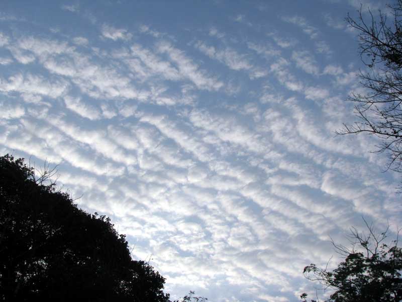
ALTOCUMULUS UNDULATUS CLOUDS
Here in the late dry season cold fronts from the north no longer are making it this far south, bringing us cooling "nortes," nor are rainstorms forming, so I was afraid that for this Newsletter I'd have no new cloud type to report on. However, just after dawn one day this week I looked up and saw the nifty sight shown at www.backyardnature.net/n/11/110410un.jpg.
Within two minutes most of those cloud-roles had dispersed, and within ten minutes the whole thing was gone. It was an ephemeral phenomenon, apparently made possible by a fleeting confluence of conditions.
These rolling kinds of clouds are known by two names, depending on how high they are. There's Stratocumulus undulatus at lower levels, and Altocumulus undulatus at higher levels. On the Internet, Hui Tai-wai of Hong Kong Observatory writes:
"To casually distinguish a stratocumulus undulatus from an altocumulus undulatus, stretch your arm and point your hand towards the cloud strips that are well above the horizon. If the strip exceeds the width of the middle three fingers, then it is most likely the former."
Using that criterion -- apparently based on the concept that the farther away something is the smaller it looks -- what's in our picture is high-level Altocumulus undulatus, for our cloud-rolls were smaller than three fingers across.
Undulating cloud patterns are formed in various ways. Often I've seen them where flowing air masses encounter mountain ranges. Sometimes they're generated at the boundary between two air layers with different densities and traveling at different velocities. Maybe the latter condition caused our undulations, for that morning a cold front from up North was stalling out to our north, held back by southerly winds blowing up from Chiapas and Guatemala.
However undulating cloud patterns are formed, the same meteorological physics is involved. Up and down motion of air somehow is induced in the atmosphere. When enough moisture is present, a cloud will form where air rises above the condensation level, but dissipate where it dips below the level. Eventually cloud strips and gaps arrange themselves in alternating patterns.