PLANTS | ANIMALS | ECOLOGY | FUNGI | GEOLOGY | GARDENING | TOOLS
MEXICAN PLANTS & ANIMALS HOME

Excerpts from Jim Conrad's
Naturalist Newsletter
from the July 24, 2011 Newsletter issued from Mayan Beach Garden Inn 20 kms north of Mahahual; Caribbean coastal beach and mangroves, ~N18.89°, ~W87.64°, Quintana Roo state, MÉXICO
MANGROVES SLOWLY FILLING WITH WATER
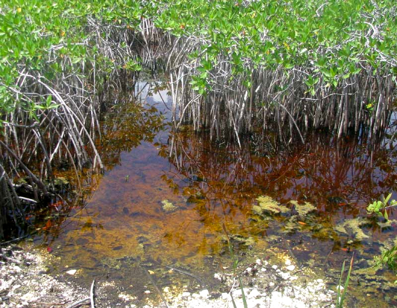
With the rainy season's gradual arrival, slowly large parts of mangrove swamps that until now have been dry are slowly filling with water. You can see a tangle of head-high Red Mangrove, Rhizophora mangle, that a month ago stood upon dry, caked mud above.
After a good rain the water rises higher, as you'd expect. However, if you really pay attention over a period of time, gradually the feeling grows that sometimes the water's average depth increases faster than the rains would seem responsible for. Also, if several dry days come along, the water may stand longer than seems reasonable. The impression is that something in addition to local rains is contributing to the mangroves' water-level rise.
Many studies show that that's the case. Remember that the Yucatán Peninsula is a vast slab of limestone eaten through and through with caves which, if occurring below the water level, carry underground rivers. In the northern and central peninsula, there are no surface rivers or streams. During the rainy season, rainwater quickly seeps underground along fractures in the limestone, into sinkholes and caverns, and merges with the water table.
The Yucatán's subterranean streams flow outward toward the nearest sea. Since the peninsula pokes northward into the zone of aridness at ±30°N we've considered at here, in the Yucatán it's much rainier in the south than in the north. Thus the general flow of freshwater in the Yucatán's underground rivers is both from south to north, as well as outward toward the coasts.
In short, those big storms I've been mentioning that most afternoons form inland but usually stay away from us on the coast, plus the even larger, more intense storms forming farther south, especially in Guatemala, are contributing to the increasing water level in our mangroves. In our mangrove picture you can see that the water is reddish. I'm guessing that the redness is tannic acid leached from Red Mangrove leaves decomposing in the mud, through which much of the standing water has filtered upwardly after its long subterranean journey up from Guatemala.
By the way, the freshwater seeping into the mangroves nowadays creates a thin lens floating atop deeper saltwater. When the rainy season ends, not only will the mangroves' water level drop, but also saltwater will intrude into places where previously there was freshwater -- as in certain wells of homes here along the coast.
The freshwater/saltwater interaction is complex and sometimes unpredictable. You might enjoy looking over the paper "Freshwater Resources in the Yucatan Peninsula" freely available online, at http://www.nap.edu/openbook.php?record_id=11875&page=6.