PLANTS | ANIMALS | ECOLOGY | FUNGI | GEOLOGY | GARDENING | TOOLS
MEXICAN PLANTS & ANIMALS HOME

Excerpts from Jim Conrad's
Naturalist Newsletter
from the January 1, 2012 Newsletter issued from Hacienda Chichen Resort beside Chichén Itzá Ruins; limestone bedrock; elevation ~39m (~128ft), N20.675°, W88.569°; central Yucatán state, MÉXICO
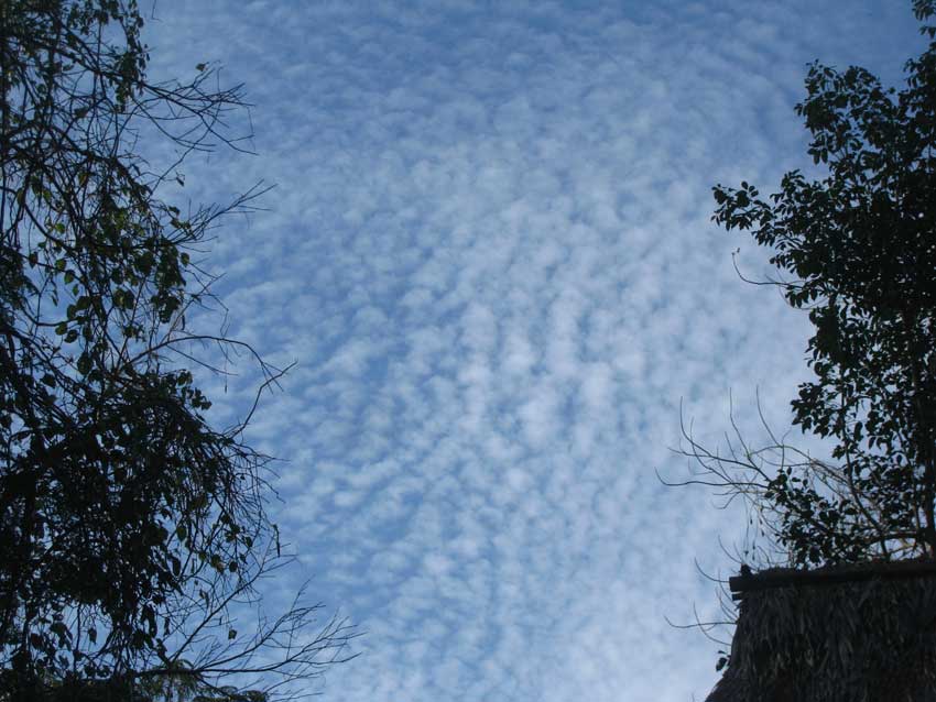
ALTOCUMULUS PERLUCIDUS CLOUDS
One morning the sky above the hut was covered with the luminous, highly fragmented cloud formation shown above.
The morning had begun with a light overcast and now the overcast was breaking up. I visualized a high, thin layer of cloud forming in the night where warmer air next to the Earth met colder air of the high atmosphere, and now early sunlight was warming the entire atmosphere, causing modest turbulence throughout, and shattering the thin cloud-lens.
Since the clouds were white and puffy like summer's cumulus clouds, and appeared high up, I guessed that they were altocumulus clouds, so that's what I looked up Wikipedia. In Wikipedia's image gallery various kinds of altocumulus clouds were shown and one picture matching ours was tagged as ALTOCUMULUS PERCULIDUS, the name ascribing to the Linnaean binomial system as if they were living organisms. Despite the "alto" in the name, altocumulus clouds are regarded as mid-level formations.
On other Web pages I learned that Altocumulus perlucidus clouds are made of water and ice, and that they're the most common form of altocumulus clouds. They often arise when shallow convection begins in a previously unbroken layer of clouds, as happened above the hut. Up North they say that seeing Altocumulus perlucidus clouds indicates that precipitation is likely within 15-20 hours if winds remain steady from NE to S, but here in the tropics that's not necessarily the case.
Also I read that Altocumulus perlucidus clouds indicate that the air on a regional basis is undergoing a gradual ascent, which often is due to a region of warmer air advancing into a region of cooler air, as when a low pressure system approaches.