PLANTS | ANIMALS | ECOLOGY | FUNGI | GEOLOGY | GARDENING | TOOLS
MEXICAN PLANTS & ANIMALS HOME

Excerpts from Jim Conrad's
Naturalist Newsletter
entry dated May 22, 2022, notes from a camping trip among hills about 7kms ENE of Tequisquiapan, Querétaro state, MÉXICO
elevation about 2020m (6700 ft), near N20.57°, W99.85°
A KAOLIN MINE & ROADCUTS
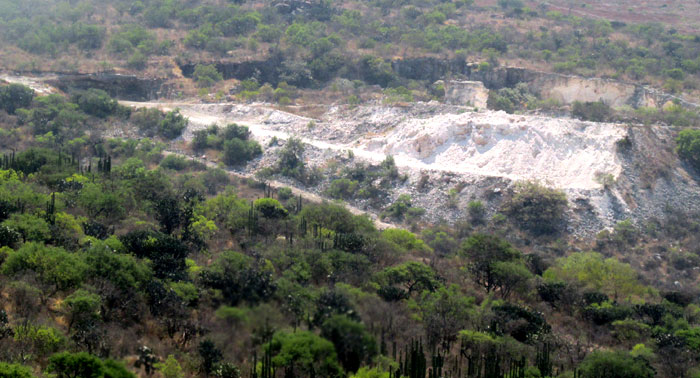
East of the tiny ridgetop village of La Higuera a valley opens up. A narrow road winds through it, headed for El Sombrerete. About halfway to Sombrerete you can look southward across the valley and see the above white scar on the steep wall of the valley's opposite side. It's a kaolin mine, and in that, and the landscape itself, there's a lot to think about.
According to the regional geology and mining map entitled "Carta Geológico-Minera Tequisquiapan F14-C67 Querétro e Hidalgo, segunda edición 1998, issued by the Mexican Geological Service, the valley we're looking across is an extension of a geological feature known as the La Caíada Graben. A graben is a technical geological term taken from German used both in Spanish and English. A graben is an elongated block of the Earth's crust lying between two faults, and displaced downward relative to the surrounding land masses. Africa's Rift Valley is the most famous graben, but that's huge, extending from Jordan southward through Africa to Mozambique, while the La Caíada Graben is only about 5kms long (3 miles) and a third of that wide.
The kaolin mine across the valley is dug into the graben's southern wall, which corresponds exactly with what's known as the Jaral Fault, the Falla Jaral, which is one of the faults formed when the graben dropped. The fault on the other side is the Desmontes Fault, the Falla los Desmontes. The mine extracts kaolin from a thick stratum exposed when the graben's floor sank. The same stratum of kaolin worked by the mine must now lie beneath the valley's floor, and probably reappears on the valley's northern slope, the other side of the sunken graben.
In fact, just below La Higuera on the valley's other side, the road cuts through kaolin, as shown below:
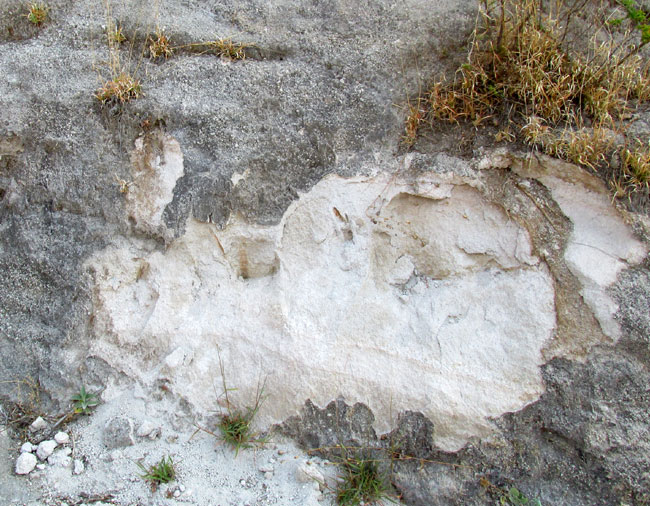
You can see that this exposure is somewhat solid and rock-like, almost like cemented talcum powder. Below this roadcut another cut exposes a mixture of kaolin and what appears to be volcanic tuff, tuff being light, porous rock formed by the consolidation of volcanic ash. Part of that roadcut is shown below:
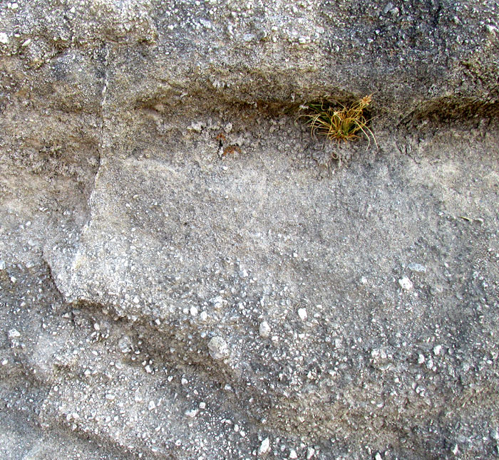
This layer is a lot grainier, and can be considered a mixture of volcanic ash and tuff, tuff being a relatively soft, porous rock usually formed by the compaction and cementation of volcanic ash and other erupted matter such as particles of volcanic glass, small crystal fragments and/or fragments of volcanic rock and lava.
The kaolin deposits, tuff, volcanic ash and the rest are related because kaolin can be formed from the geological-time-scale weathering of volcanic rock, tuffs and ashes, as outlined in a 2003 research article by O. Isik Ece and others entitled "Alteration of Volcanic Rocks and Genesis of Kaolin Deposits in the Şile Region, Northern Istanbul, Turkey. I:Clay Mineralogy."
And this area's entire landscape results from ancient volcanism. The hills are mostly composed of the volcanic extrusive rock rhyolite -- extrusive referring to rock formed by the cooling of lava "extruded" from a volcano. Towns in the nearby level lowlands are built on sediment eroded from these rhyolite hills.
We're a bit north of the Tans-Mexican Volcanic Belt cutting east-west across central Mexico, with its several snow-capped peaks. Volcanoes in the belt are still active. However, according to Luca Ferrari and others in the 2012 publication "The dynamic history of the Trans-Mexican Volcanic Belt and the Mexico subduction zone," between ~11 and ~3 million years ago (late Miocene to late Pliocene Epochs) a pulse of volcanism swept across all of central Mexico north of the volcanic belt, and we're in that area.
One feature of that sweeping "pulse of volcanism" occurred with the formation of the Amazcala Caldera located about 30kms northeast of Querétaro City. It's 14 x 11 kms in size (8.7 x 6.8 miles) and was active from 7.3 to 6.6 million years ago. In geology, calderas are large depressions formed when a volcano erupts and collapses. A good guess is that our kaolin derives from the tuff and ash erupted by the volcano that eventually collapsed to form the caldera.
In fact, the above-mentioned geologic-mining map, which indicates the mineral nature and age of the landscape's surface area, shows that the exposed volcanic material in our graben/valley east of La Higuera was erupted about 4.5 million years ago. That gives millions of years for the weathering needed to convert tuff and ash to the kaolin that's mined today.
By the way, 4.5 million years ago when those volcanoes erupted, members of the genus Australopithecus, from which modern humans are considered to have arisen, were living in Africa, and over the Earth in general the planet was changing to a cooler, drier, seasonal climate, reducing tropical species but favoring deciduous and coniferous forests and grasslands.
Also by the way, kaolin is remarkably useful stuff; some people even eat it. The uses are too varied to go into here, but Wikipedia has a Kaolinite page that goes into kaolin's uses very well.
But that's a kaolinite page and our mine is for kaolin. Kaolin is to kaolinite as limestone is to calcite. Calcite is a crystal-forming mineral with the chemical formula CaCO3, while limestone is a rock composed mostly of calcite but also various other minerals in varying amounts, none of which form noticeable crystals. In the same way, kaolinite is a mineral with the chemical formula of Al2Si2O5(OH)4 which can form crystals, even though usually it doesn't, just making microscopic plates and clusters of plates aggregated into compact, claylike masses. And kaolin is mostly kaolinite, but also with various other minerals in varying amounts, none of which form noticeable crystals.
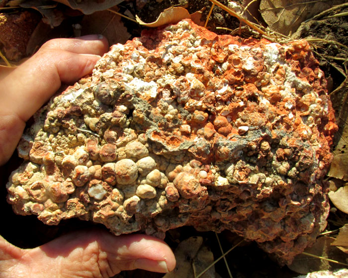
Over geologic time, Nature can do all sorts of things with volcanic ash, including the above. The rounded items are spherulites, which are small, rounded bodies commonly occurring in igneous rocks containing lots of silica, which is exactly the case with our rhyolitic hills and all this tuff and ash. In the field of petrology, spherulites in all their forms and manners of being are a big subject. Wikipedia provides a good introduction on its Spherulite Page.