
PLANTS | ANIMALS | ECOLOGY | FUNGI | GEOLOGY | GARDENING | TOOLS
Excerpts from Jim Conrad's
Naturalist Newsletter
from the February 10, 2002 Newsletter issued from the woods of the Loess Hill Region a few miles south of Natchez, Mississippi; elevation ~200ft (~60m), ~N31.42°, ~W91.41°; USA
SNAIL SHELLS IN THE LOESS
You simply can't walk in the bayous here without finding fossils. Before I tell you about them, remember that in this area a bayou is a special kind of deep, steep-walled ravine or gully, not the broad, dead-water swamps or tidal basins called bayous in Louisiana.
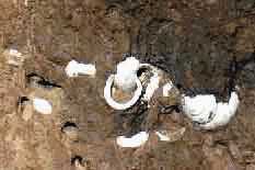 Our most abundant bayou fossils are the white snail shells found embedded in the loess forming the bayous' almost-vertical walls, some of which are shown at the right. If you are fuzzy about what loess is, click on the "Loess Hill Region" link at the top of this section.
Early in the 20th Century similar loess-embedded snail shells were used by geologists to figure out when our loess was deposited. A few decades later snail shells just like ours were removed from a roadcut through loess at Vicksburg 70 miles north of here and their age was determined using Carbon-14 dating. Shells toward the top of the roadcut were found to be 17,850 years old, give or take 380 years. Shells from the middle of the cut were placed at 19,250 years old, give or take 350 years, and shells at the bottom of the loess registered at 25,300 years old, give or take 1,000 years.
Of course it makes sense that the deeper you go in the loess, the older the shells would be, since what's on bottom is what was deposited first. I provide a brief explanation of how Carbon-14 dating works at https://www.backyardnature.net/loess/c14.htm. These dates -- between 17,850 and 25,300 years ago -- marked the end of the last Ice Age. At that time the ice sheet north of the Ohio River was melting, producing enormous quantities of meltwater that passed by our present location on its journey to the Gulf of Mexico. The Mississippi River then was a vast "braided stream" much larger than the present river. Its water gushed over a vast plain bearing unfathomable amounts of gravel, sand and silt.
As now, during winters less water flowed because precipitation north of here was frozen. When water was relatively low, large mudflats and many islands appeared between the big river's widely separated shores. It's theorized that mud coating these emergent land masses would dry, then strong westerly winds would stir up silt particles from the dried mud and carry them as dust. This dust would then drop on the Mississippi's bluffs and highlands immediately to the east -- where we are now -- and of course that deposited dust became our loess. It was a slow process, with thousands of years of dust deposition leaving only a few hundred feet of loess.
Life atop the accumulating loess went on as always. And when snails died their shells remained as stonelike fossils. The 25,000-year old shells pried from Laurel Hill's loess today look just like last year's bleached ones atop the soil.
There are other fossils in our bayous, even ones much more interesting than these, but I'll wait for another time to tell you about them.