
PLANTS | ANIMALS | ECOLOGY | FUNGI | GEOLOGY | GARDENING | TOOLS
Excerpts from Jim Conrad's
Naturalist Newsletter
from the March 16, 2014 Newsletter issued from the Frio Canyon Nature Education Center in the valley of the Dry Frio River in northern Uvalde County, southwestern Texas, on the southern border of the Edwards Plateau; elevation ~1750m (~5750 ft); N29.62°, W99.86°; USA
ALTOCUMULUS CASTELANUS, or JELLYFISH CLOUDS
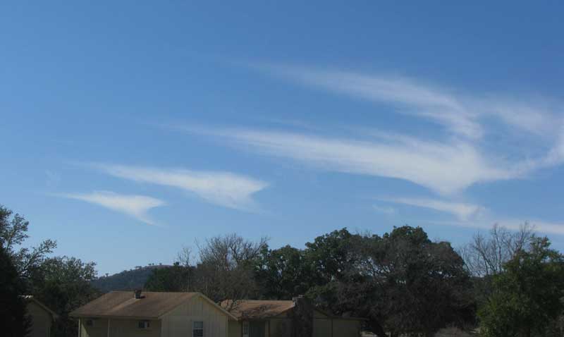
The other day it was cool and dry and we were expecting a warm front out of Mexico to come up from the southwest possibly bringing us some desperately needed rain. At mid day unusual clouds appeared in the southwest and I figured they might be the leading edge of that front. That's them above
Being halfway "white and fluffy" I pegged them as cumulus clouds, and since their tops were wispy almost like high-altitude cirrus clouds composed of ice crystals, they must have been relatively high cumulus, or "altocumulus." The Clouds-Online.Com website lists thirteen altocumulus species, subspecies and special forms, so which was this? Google's image-search feature using the keyword "altocumulus" quickly turned up named pictures of clouds like ours.
They're Altocumulus castelanus clouds, sometimes known as jellyfish clouds because of the small part dangling below each cloud, reminiscent of tentacles beneath jellyfish floating on the water's surface. I read that Altocumulus castelanus form when moist air becomes trapped between layers of dry air, so probably that day the leading edge of our expected Mexican front with its moisture probably was indeed wedging its way into our too-dry air.
The "tentacle" part of the cloud, known as the "trailing virga," consists of raindrops evaporating as they fall from the cloud, never to reach the ground. Several cloud types, especially in arid areas, produce virgas, so that's a good word to remember.