May 3, 2015
RÍO LAGARTOS IN THE LATE DRY SEASON
Busing into Río Lagartos after nearly a month on the road I saw that things here had changed. First, the town was busier than normal, with more folks in the streets than I'd seen anytime here, except during Christmas and Easter. The cause of the activity was a week-long, lucrative fishing season for sea cucumber. More on that below.
The other big change was the heat and dryness. The heat came to my attention as soon as I arrived in Mérida at dawn last Sunday morning. Newspapers were on sale outside the bus station's exit, and the largest title among them was, "Calor Histórico en Mérida" -- "Historic Heat in Mérida." On Monday the street temperature reported there was 43°C, or 109.4°F.
Approaching Río Lagartos on the bus, the landscape looked as if a giant hair-drier had been blowing scorching air on it since my departure on April 1. Most of the landscape was grayish brown, and most ranchland and roadsides had undergone the yearly burn and were blackened, where ranchers had set semi-controlled fires that cinderized dry grass, herbs and shrubs.
Ashes from the yearly burning contain nutrients that fertilize a spurt of new pasture growth for livestock when the rainy season returns. The burnings also -- for days on end -- fill the entire landscape's air with smoky haze and odor, converts huge amounts of biomass to green house gases, and in the long run creates organic-matter-depleted soil which gradually loses its structure and ability to support a complex ecosystem. The blackened landscape absorbs the sun's radiant energy, making it even hotter than it already is.
However, this yearly burning at the end of the dry season is so deeply ingrained in peoples' minds here that maybe it's impossible to change things. Moreover, it's easy to see with one's own eyes that burning causes greener, lusher grass to sprout when the rainy season returns, but it takes years of paying attention and analysis to realize that it destroys soil, contributes to global warming, and adds to the list of threats endangering Life on Earth.
*****
SEA-CUCUMBER SEASON
I arrived in Río Lagartos to find my tour-guide friends and students out fishing for sea-cucumbers. Our Sea-Cucumber Page is at https://www.backyardnature.net/yucatan/sea-cuc.htm.
That page shows a sea-cucumber smaller than ones being collected here nowadays. The average ones brought in during this fishing season are about 10 inches long (25cm), with big ones reaching a foot long (30cm). A fisherman tells me that four species occur in the waters north of Río Lagartos, one of them quite rare.
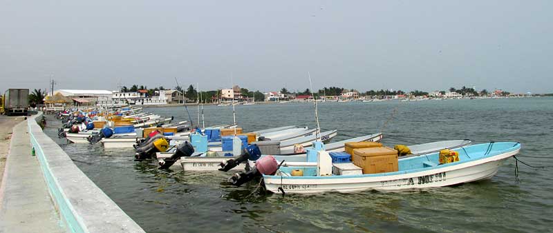
This is a short, week-long fishing season just for sea-cucumbers, and for the event many fishermen with their boats have come to Río Lagartos from fishing villages all along the coast, from Campeche on the peninsula's eastern side to Holbox on the Caribbean side. In Río Lagartos the number of local fishing boats always is astonishing, but now twice as many are tied up along the Malecón's storm wall. On days when it's too windy to go out, the streets are filled with wandering young men, and at night the bars and restaurants are rollicking. It's not just fishermen added to the town's population, but also drivers both of trucks used to transfer the catch inland, and big semis that haul in tons of ice to keep the catch cold, and peddlers of many wares. The big semis park along the Malecón and the drivers just hang out until their ice is gone. Some sleep in their cabs and lie there during the day listening to music as meltwater dribbles onto the street.
This week about half the days were too windy for the fishermen to go out, so everyone hopes the fishing ban will be lifted some extra days next week to make up for lost time at sea. The wind is important because sea-cucumber numbers near shore have been depleted. Nowadays to make money you have to go 15-20 miles (25-30kms) into the sea, where on windy days waves are dangerous for boats as small as those used here. You can see part of a flotilla of visitor boats from El Cuyo up the coast tied to the storm wall along the Malecón south of town, with a big semi parked full of ice and with Río Lagartos in the background -- and boats tied up along shore the whole visible distance, and on the peninsula's other side as well, with each boat carrying a big, cubical ice cooler for holding sea-cucumbers -- at https://www.backyardnature.net/n/15/150503cc.jpg.
I asked a fisherman why, since sea-cucumbers occur all along the Yucatan Peninsula's coast, so many fishermen left their home ports to fish here. He replied that in other places the fishing bans have not been honored as much as they have been here, so this is the only place where good fishing remains. Then he added that even here there's a lot of cheating and underhanded deal making with marketing intermediaries; there's a thriving black market for sea-cucumbers.
All this activity is good news for local folks with rooms to rent, food to sell and beer to drink, but it has its dark side. First, it's hard on the sea-cucumbers. Two fishermen told me about their first day out collecting sea-cucumbers. The first went with an old fisherman who didn't want to go far offshore because the waves were too big. The second one went far out despite the waves, into territory that hadn't been overfished. The second fisherman made ten times the money as the one who stayed in Río Lagartos's traditional fishing ground.
Sea-cucumber fishing is hard, dangerous work. The fisherman collects animals on the ocean floor, and the farther out the boat is, the deeper the water gets. The fisherman wears a face mask and breathes through a hose through which air is pumped from a tank in the boat. Often the men work so deep that getting the bends is a big problem. Every fisherman has his sea-cucumber story about coming up too fast, or from having his air contaminated in some way. Lots of them have made fast car trips to Tizimín about half an hour south of here, where there's a decompression chamber.
But, people collect sea-cucumbers because it brings in lots of money -- the catch being exported to Asia. A New York Times article in 2013 reported that in China a single pound of dried sea-cucumber was selling for US $300. That article also describes community-destroying animosities that arise among fishing cooperatives here in the Yucatan when outsiders try to fish in grounds claimed by others. The Mexican Navy sometimes has been deployed, and highway check points try to slow down sea-cucumber smuggling. The New York Times article is freely available online here.
This Thursday morning when I went to buy my daily tortillas, the old lady who sells them in her dark little store was reading a newspaper with a sad look on her face. The lead story was about how this week at El Cuyo just east of here, men with rifles stormed a fishing cooperative's warehouse, threatened and gagged the watchmen, and stole 3.5 tons of sea-cucumbers valued at around a million pesos -- US $65,000.
In Spanish, the story is freely available online here.
*****
SAN JUAN DEL MONTE ECOLOGICAL RESERVE
In our April 12th Newsletter I described visiting San Juan del Monte Ecological Reserve in the mountains of northern Veracruz state. That Newsletter is at https://www.backyardnature.net/n/15/150412.htm.
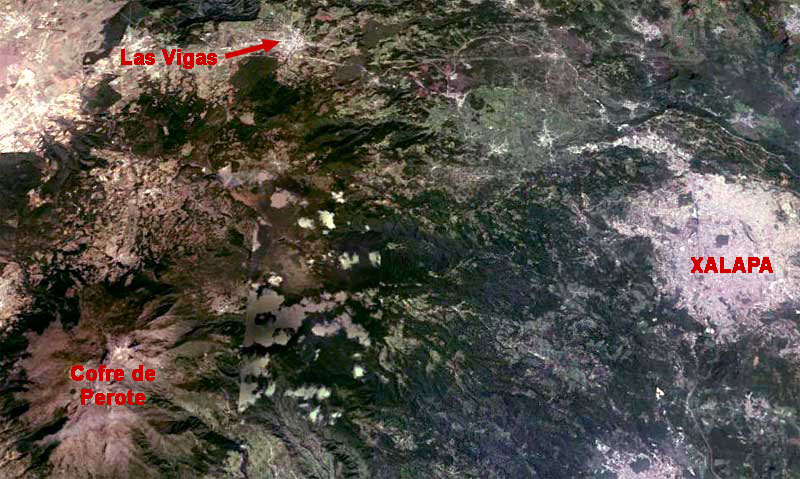
Now I can better introduce you to that nice place. First, take a look at the area as seen from Google Earth's satellite, at https://www.backyardnature.net/n/15/150503vg.jpg.
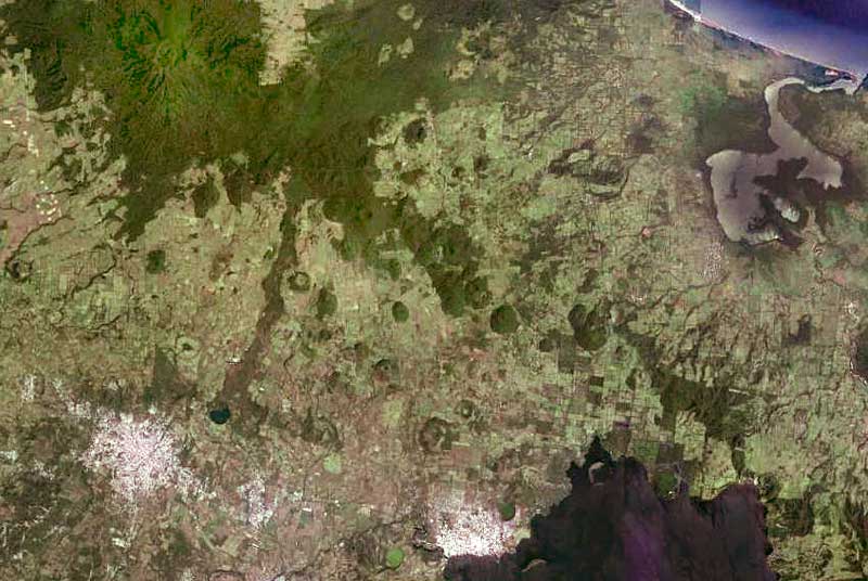
Xalapa at the right in that image is the main town in that region and where I bused to overnight from coastal Veracruz, with my ears popping regularly as the bus climbed in elevation. Xalapa stands at about 4600 feet (1400m) in elevation. From Xalapa I took an early morning bus up the ever-ascending highway that in the picture shows itself as a white thread shooting out of Xalapa's northwestern corner, then running along the top of the picture until it passes just south of Las Vigas, where I disembarked.
In Las Vigas I bought some food and water, and hiked into the forest that in the photo appears as a dark, squarish blob on the southwestern side of town. Las Vigas's elevation is given as about 7965ft (2428m), so it was nice and cool there. In the picture's bottom, left corner, the area with flame-like patterns radiating from a central white point is Cofre de Perote Volcano, whose peak is given as 14,282 feet (4,282m), so the whiteness at the volcano's center is snow.
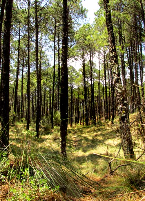
South of Las Vigas the landscape is developed on black basaltic rock and tilts upward toward Perote Volcano in the southwest. The closer you get to Perote, the steeper the slope becomes. The basalt is formed from lava ejected back when Perote was active. A bit inside the forest a sign welcomed me to the "Reserva Ecológica San Juan Del Monte." You can see what the forest looked like at https://www.backyardnature.net/n/15/150503vj.jpg.
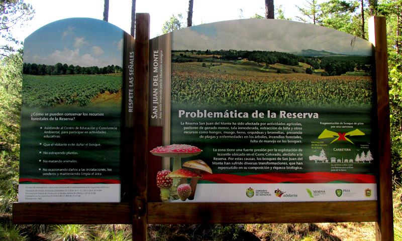
Notice that the pines all appear to be of the same age, with no young trees being established for the next generation, and that the forest floor is carpeted with dense clumpgrass. At the Reserve entrance an informative sign described the Reserve's history. You can see that sign at https://www.backyardnature.net/n/15/150503vh.jpg.
The sign informs us that "San Juan del Monte has been affected by agricultural activities, minor livestock grazing, immoderate tree-cutting, the gathering of firewood and other resources such as mushrooms, moss, hay, orchids and bromeliads, plus tree diseases, forest fires, and the lack of forest management." The sign goes on to speak of the special case of mining "tezontle" in the area of Cerro Colorado. Tezontle is a porous volcanic rock, usually reddish or blackish, typically sold as a small-grained gravel for roads and landscaping. I've seen it sold in bags at garden centers in the US.
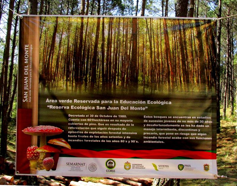
A little deeper into the forest a large informational canvas suspended between trees provided more information. That canvas is shown at https://www.backyardnature.net/n/15/150503vi.jpg.
The canvas says that the Reserve, which covers 601 hectares (1485 acres), results from a decree made in 1980. The forest was intensively exploited up to the end of the 1970s, and suffered from forest fires during the 1980s and 90s. The forest is in a young stage of forest succession no more than 30 years old, and the canvas candidly admits that over the years the forest's management has been intermittent, leading to a precarious situation, especially with regard to forest fires. You can imagine what might happen during the dry season if the dry grass in the first photo is set ablaze.
*****
BASALT
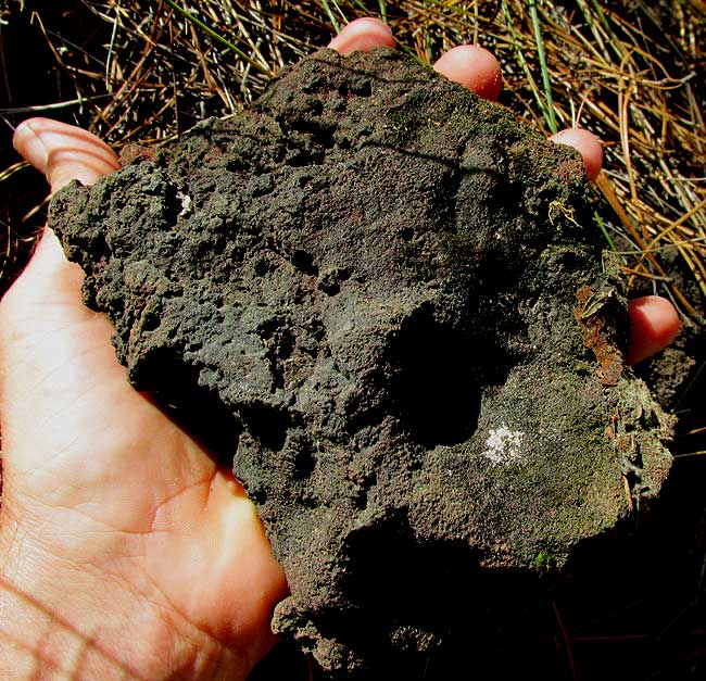
Above you saw how grassy the forest floor was at Reserva San Juan del Monte. Walking through the forest wasn't as easy as it looks like it'd be. That's because in many places the basaltic rock forming the bedrock is exposed in jaggedly irregular forms. Often there are holes in it covered with grass so when you step there your leg gets swallowed and you lose some skin. You can see a rock of basalt, typically black and with the texture of frozen grits, at https://www.backyardnature.net/n/15/150503bs.jpg.
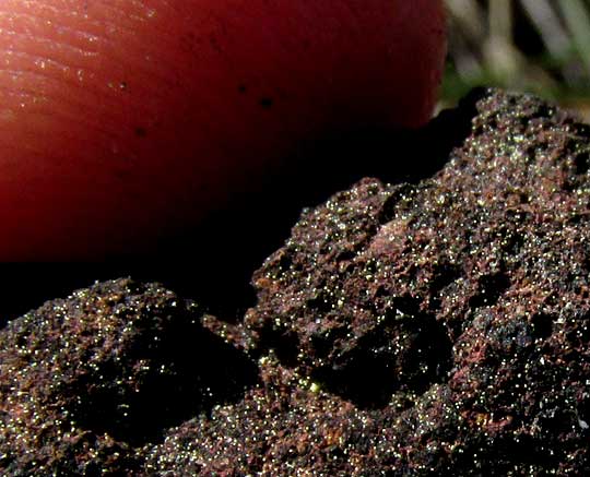
A close-up of the above rock, with ridges on my fingertips providing scale, reveals tiny, white thingies embedded in the black rock matrix, with larger splotches of dark reddish rustiness here and there, at https://www.backyardnature.net/n/15/150503bt.jpg.
Basalt is the most abundant of the planet's bedrocks, though over very large areas you can't find it locally; I never saw basalt in Kentucky. That's because basalt is of igneous origin, typically associated with volcanic activities, and Kentucky's landscape is developed atop sedimentary rock, especially limestone, sandstone, and sediment itself. The Reserve's basalt has formed from ancient lava issued from Cofre de Perote Volcano.
Basalt starts out as gravy-like volcanic magma or lava at or near the landscape's surface. Its position at or near the surface is important, because there it cools relatively fast -- so fast that mineral compounds in the molten magma or lava don't have time to form large crystals. Magma that cools deep within the earth may cool for centuries, during which time its constituent mineral compounds have the time to coalesce and solidify into large, sometimes gigantic crystals. The resulting rock bearing large crystals may have the same mineral composition as our basalt, but its texture will be very different, and so, by definition, won't be basalt. A rock with the same chemical composition as our basalt at Las Vigas, but with a coarser texture, would be called gabbro.
Basalt does contain crystals, but they're so tiny that the naked eye can't make them out. Or maybe they're just barely visible, which is the case in our close-up, where the tiny, white objects are either microscopic white minerals or reflective crystal faces.
If erupted lava lands in water where it cools very rapidly, then the lava's mineral compounds don't even have time to make microscopic crystals. The magma freezes into something like glass with no or very little crystaline structure at all. Such rock, usually black, is called obsidian.
Basalt rock contains a fair amount of iron, so the rusty-red stains on our rock close-up are simply areas with higher concentrations of iron that has rusted when exposed to the air. When something rusts, its iron atoms combine with oxygen atoms to form iron oxide, which is rust.
Identifying a rock type can be a tricky business, especially because there are no strict boundaries between rock types. For example, there's limestone and there's shale, and there's limy shale, and all gradations between them. It's the same way with basalt. I knew to call the black rock at Las Vigas basalt because we were in a volcanic area, the rock type most to be expected in such areas is basalt, and our rock had the color and texture of basalt I'd seen elsewhere.
More technically, the definition of basalt is that it's an igneous rock of a certain fine texture (frozen grits) composed of less than 20% quartz and less than 10% feldspar by volume, and with at least 65% of its feldspar in the form of plagioclase.
*****
THE HYDROLOGICAL RESERVE ABOVE SAN ANDRÉS TUXTLA
On my return trip from north of the border, I camped in the volcanic mountains north of San Andrés Tuxtla in southern Veracruz state. The adventure of getting into that area was described in our last Newsletter, archived at https://www.backyardnature.net/n/15/150426.htm.
You can see a Google Earth satellite image of that area at https://www.backyardnature.net/n/15/150503tx.jpg.
In that image, the large, bluish area at the lower right is the northern part of Laguna Catemaco, or Lake Catemaco, an important tourist destination in that region. The white blob on the lake's western shore is the town of Catemaco. To reach the hydrological reserve I bused into the white blob at the image's lower, left, which is the town of San Andrés Tuxtla. The image shows a long, slender finger of dark greenness extending from dark, mountaintop forests at the picture's top. The finger is a kind of corridor inside which runs the road I took from San Andrés to the reserve. To me it had seemed that the trip upslope took place in a largely forested zone, but now I see that the forests were just along the road. If you look closely at the above image you can see numerous small volcanic craters throughout the area, and a tall one in the top, left corner.
The reserve was 1186 acres (480 hectares) in extent, and the air was refreshingly cooler than the very hot lowlands just below, though the elevation was only about 4000 feet (1200m) high. Last week I noted the presence around my tent of Spider Monkeys, Keel-billed Toucans, Montazuma's Oropendulas, Horned Guans, and lots of fireflies and mosquitoes. Tree trunks in the reserve were so heavily covered with mosses, ferns, liverworts, bromeliads, orchids and peperomias that the forest could be considered borderline cloud forest. An isolated, mountaintop island of Sweetgums lived there. I photographed some of the most interesting plants and will be profiling them as time permits.
The first profile appears below:
*****
STRAP FERN
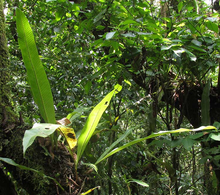
Outside the tent door at my first camping site in the hydrological reserve above and north of San Andrés Tuxtla, Veracruz, a fern grew very picturesquely on the mossy, leaning trunk of a tree. You can see it, the picture taken through the tent door, at https://www.backyardnature.net/n/15/150503cp.jpg.
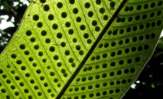
Several epiphytes -- plants living on other plants -- somewhat similar to this also could be seen in the area. Among them were orchids, aroids and ferns. Fortunately, this plant was prodigiously producing reproductive bodies in neat rows on the bottom surface of its arching blades, so it was easy to figure out which kind of plant it was. You can see those reproductive bodies backlighted by sunlight at https://www.backyardnature.net/n/15/150503cq.jpg.
The dark, round spots are sori (singular sorus), sometimes called fruit-dots. Each sorus is a compact cluster of many nearly microscopic items called sporangia, and inside each sporangium there are dust-like spores, which in nature will germinate to form new plants. In other words, our sunlight-glowing epiphyte is a fern, because ferns bear sori composed of sporangia containing spores.
Sori come in many shapes, sizes and anatomical contexts, so in fern identification usually sorus configuration is of utmost importance. Right away I recognized these round sori as practically identical to North America's common polypody ferns, and that helped a lot in tracking down this fern's identity.
It's a kind of strap fern, genus Campyloneurum, in the same fern family as North America's polypodies, the Polypodiaceae. Between 25 and 50 strap fern species are known, depending on your expert. All occur in the tropical and subtropical Americas, and their taxonomy isn't well understood. On the basis of this fern's size and the configuration of its sori, my guess is that this is CAMPYLONEURUM COSTATUM, sometimes known as the Tailed Strap Fern, occurring from southern Florida south to northern South America, including the Caribbean area.
The main feature separating it from other similar species is that its sori are lined up in only one line, not two or more, between the frond's secondary veins. A better known species, Campyloneurum phyllitidis, often grown in pots and in tropical gardens, has two rows of sori between each pair of secondary veins, and that's the same case with C. xalapense, known to grow in this area.
Whatever its name, it certainly is a pretty fern when growing in the wild in a random beam of sunlight.
*****
LOTUS-LEAVED BEGONIAS
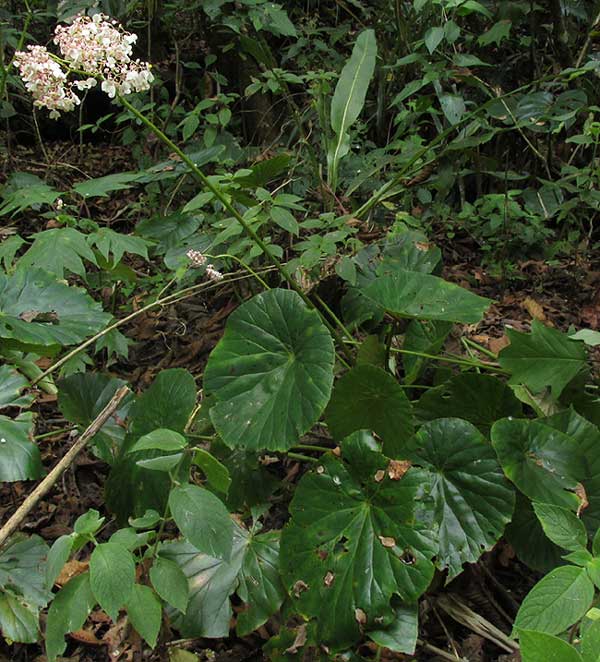
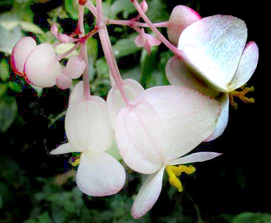
Right beside the epiphytic Strap Fern, in full blossom, there was a wildflower of a kind never found in temperate forests, shown at https://www.backyardnature.net/n/15/150503bg.jpg.
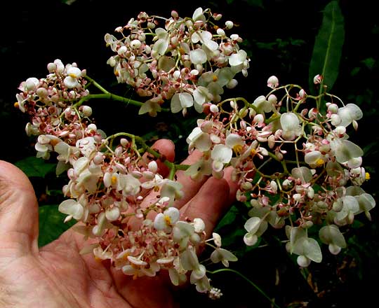
Anyone who deals much with the North's potted house plants will recognize this as a begonia, though one much larger than those normally found in pots. This one grew about waist high. A close-up of the plant's flowering head is at https://www.backyardnature.net/n/15/150503bh.jpg.
Closer still, you can see some typical begonia flowers, at https://www.backyardnature.net/n/15/150503bi.jpg.
Begonias are "monoecious," meaning that separate male and female flowers are produced on the same plant. Those in the picture are female flowers, on which the fingerlike yellow things are styles bearing twisted stigmas. The two white, petal-like things below the styles are indeed the flower's two petals, and below the petals (above them in the picture) the broad, papery items are "wings" on the ovary. One visualizes the ovary maturing into a fruit with the dried wings helping in wind dispersal.
It can be a challenge to identify wild begonias to species level because the genus Begonia is a big one, with more than 1,600 recognized species. It's considered the sixth-largest genus of all angiosperms. Happily, the online Flora de Veracruz has its Begonia volume finished, so I could key out our pretty cloud-forest denizen.
With un-lobed, roundish leaves arising from a thick, short rhizome, or underground stem, attached to their petioles near the center of the blades' undersurfaces (the leaves are "peltate"), and with the plant's and flowers' large size, this Begonia keyed out fairly easily to BEGONIA NELUMBIIFOLIA. Long ago gardeners discovered the charm of this robust species, so it bears established English names, the most commonly appearing being Lotus-leafed Begonia and Water-lily Begonia, referencing the species name, Nelumbo being a water-lily genus.
Our Lotus-leafed Begonia occurs spottily in southern Mexico and south through Central America to Colombia. The waist-tall ones in the shadowy understory around my tent actually were small ones. Out on the road through the reserve where plants not only had plenty of moisture but also sunlight, they grew head tall, making them the biggest begonias I'd ever seen.
Folk medicine regards this begonia's leaves as good for treating bumps and bruises. Typically, you mash the semi-succulent leaves with a little water and apply the moist pulp to the injury, tying the pulp in place with a rag and changing the pulp three times a day.
*****
FENCE TREES
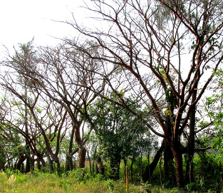
Surely the most abundant of all trees in Veracruz state as well as much of the rest of lowland, humid, tropical Mexico is the species shown at https://www.backyardnature.net/n/15/150503bu.jpg.
You can see that here during the late dry season the trees are mostly leafless, but even at this distance it's easy to recognize who the trees are. The main field mark is that they've been planted in a line, with barbed wire tacked to their trunks so that they serve as living fence posts, and the other item to notice is that their bark is dark reddish, and smooth but flaky. We've looked at this tree before, so you can see a close-up of the trunk's peeling-off, reddish, papery flakes on a tree in Querétaro at https://www.backyardnature.net/q/bursera.jpg.
Often this tree is called Gumbo-Limbo in English texts, but in Mexico each region has its own name. My pirate taxi driver into San Andrés Tuxtla called it Morena but back in the Yucatán it's called Chakah, and local guides dealing with tourists sometimes call it Naked Indian Tree or Tourist Tree, the latter because its trunk blisters like a sunburned tourist. It's BURSERA SIMARUBA of the little-known, tropical Bursera Family.
One reason the tree is so commonly encountered is that it's a tough, adaptable species able to endure many abuses. Just poke a stick of it into the ground, it roots, and makes a new tree. Living fences such as the one in our picture are the norm throughout tropical Mexico wherever there's enough rain for them and it doesn't get too cold. Another reason for their abundance is that over the years various reforestation programs have provided seedlings to country folks willing to plant them. The tree's wood is too watery to make good firewood, and too weak and brittle to be good building material, but its fence-post service and the cool shade it produces endears it to everyone.
Gumbo-Limbos aren't the only fence trees used in Veracruz and elsewhere. Sometimes the similarly resilient but gray-trunked Madre de Cacao, Gliricidia sepium, is used. Our page for that tree is at https://www.backyardnature.net/yucatan/gliricid.htm.
Also, sometimes you see Australian Pines, Casuarina equisetifolia, being used, which one wonders about, because sometimes this invasive species "goes wild," displacing native species. Also, Australian Pines are highly "allelopathic" -- producing chemicals that inhibit the growth of other species around them. Our Australian Pine page is at https://www.backyardnature.net/yucatan/casuarin.htm.
*****
FEATURED ESSAYS FROM THE PAST:
"Pup with A Wagging Tail" from the February 6, 2012 Newsletter, at https://www.backyardnature.net/n/p/120206.htm
"Quantum Mechanics & Balché" from the November 23, 2005 Newsletter, at https://www.backyardnature.net/n/p/051123.htm
*****
Best wishes to all Newsletter readers,
Jim
All previous Newsletters are archived at https://www.backyardnature.net/n/.