PLANTS | ANIMALS | ECOLOGY | FUNGI | GEOLOGY | GARDENING | TOOLS
MEXICAN PLANTS & ANIMALS HOME

Excerpts from Jim Conrad's
Naturalist Newsletter
entry from field notes dated April 16, 2022, taken in disturbed/reforesting borderline cloudforest within 1km of Valle de los Fantasmas, elevation ±2,320m (7600 ft), with limestone bedrock; about 40kms (24 miles), straight-line, ESE of San Luis Potosí, San Luis Potosí state, MÉXICO, (N22.06°, W100.62°)
CALCITE-FILLED LIMESTONE FRACTURES
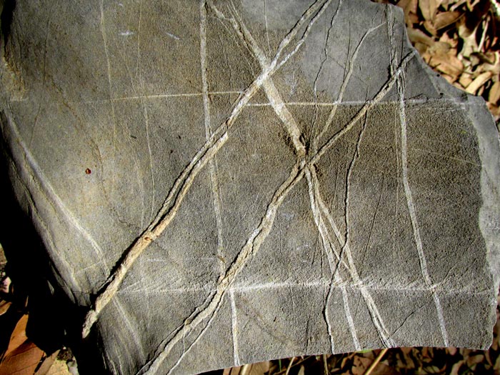
Near my tent on the valley floor, someone had left a cantaloupe-size limestone rock on the ground, apparently gathered for circling a campfire, but never used. It bore crisscrossing white lines, as shown above. It's to be noticed that the larger lines run somewhat parallel with certain other larger lines, but not exactly so. Below is a close-up of the rock's surface, with the rock angled so that slanting sunlight exposes more details:
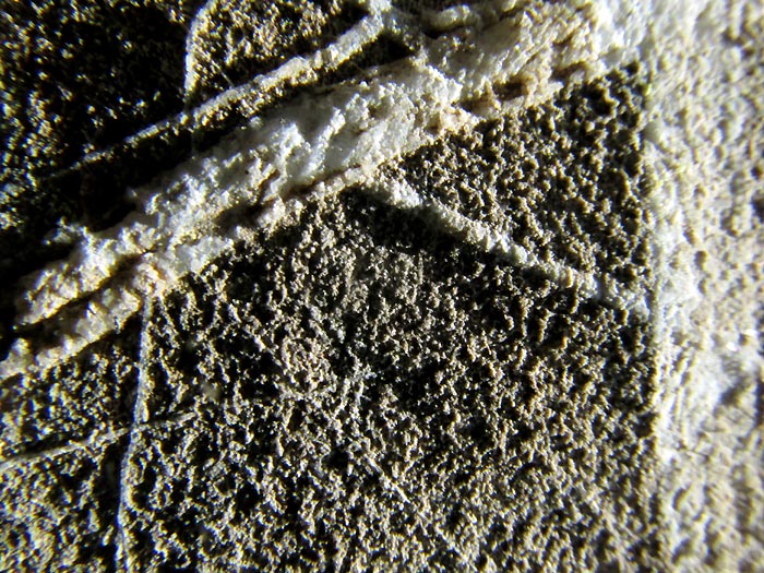
Smaller lines occur in a more haphazard manner than the larger ones, and the rock's matrix displays a grainy structure. The grains of the rock's matrix are close to the same tiny size throughout, and the grains are somewhat spherical. However, the fused-together grains at the surface of the white lines display various sizes, and if you look close you can find tiny flat surfaces and straight, sharp edges.
At first glance the impression is given that we're seeing white, slender lines of something strung across the rock's surface. However, another limestone rock lying nearby suggests the true nature of the white lines:
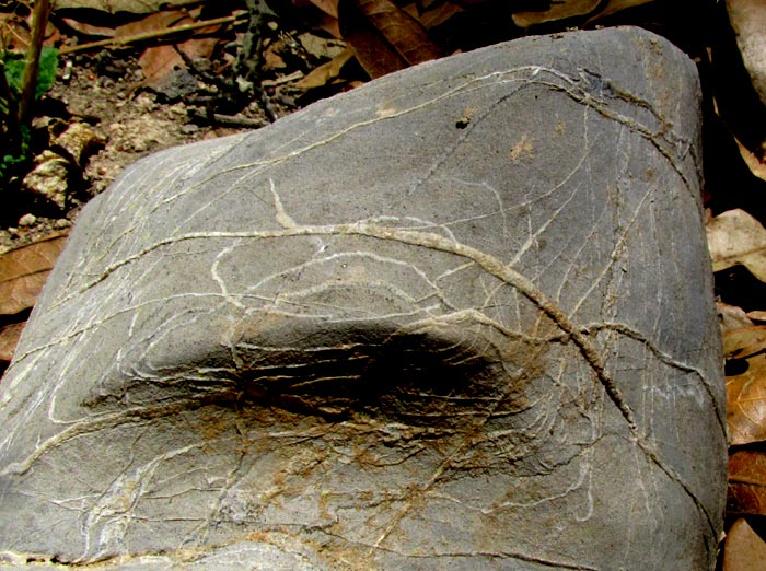
When the rock curves, the white lines curve with it. Moreover, the white lines arrange themselves like elevation lines on a topography map whose concentric circles announce a hill or a depression. The rock's concentric circles are best seen in the above picture's center where the rock's part projecting toward us displays several of them, the smallest circle surrounding the rock's nearest-to-us point.
The implication is that these straight, white lines on the gray limestone rock are not just lines on the rock's surface, but rather the broken edges of thin layers of white matter suspended within the rocks like thin sheets of white paper.
At this point, already we can visualize quite a history for these rocks.
Keeping in mind that limestone rocks are sedimentary and usually begin as muck on the sea floor, and that much limestone rock has formed from very tiny shells of free-floating, one-celled organisms called foraminifera falling like snow to form the muck, a good bet is that the similar-size grains on our rocks' surfaces are individual fossil foraminifera. Foraminifera have been living in the Earth's waters, dying, and having their calcium-carbonate-rich shells fall to the seabed for over 600 million years, and they're still doing that today. Wikipedia provides a fine Foraminifera page.
Of course, if limestone is a sedimentary rock largely or almost entirely composed of crammed-together fossil shells from an ocean's floor, and here our tent site lies ±2,320m (7600 ft) above sea level, this area probably has been uplifted by powerful forces within in the Earth, as described on Wikipedia's Plate tectonics page.
And it's true that geology maps show many major faults in this area, as well as igneous outcroppings. Faults are cracks in the Earth's crust caused by tensions created when part of the crust is pushing in one direction while nearby another part of the crust isn't, or is pushing in another direction. If you bend a sheet of glass too much, it'll fracture. It's the same story here.
So, geology maps of this area tell us that limestone rocks found here were formed at the bottom of a sea about 90 million years ago during the Upper Cretaceous period. Because limestone is brittle, all the crustal pushing and shoving caused it to fracture. Some fractures created faults running for many miles. Other fractures were smaller, and some were very small. The lines in our limestone rocks indicate very minor cracking. Sometimes the fracture-causing pressures came from one direction, sometimes from another, resulting in certain fracture planes crisscrossing others.
Once the rock was fractured, very slowly calcium carbonate migrated by various ways into the fractures, and precipitated into granular calcite mineral, calcite being the crystalline form of calcium carbonate. The calcite crystals were fused together, but when the exposed edges of the sheets of calcite within the limestone are observed at the rocks' surfaces, in places flat crystal surfaces can be seen, and the sharp edges of crystals.
When you know a little basic geology and are willing to look things up as you start noticing more and more geological features, every rock will tell you a story.