PLANTS | ANIMALS | ECOLOGY | FUNGI | GEOLOGY | GARDENING | TOOLS
MEXICAN PLANTS & ANIMALS HOME

Excerpts from Jim Conrad's
Naturalist Newsletter
Entry dated March 6, 2024, from notes taken in semidesert about 2kms south of Higuerillas, Municipality of Cadereyta de Montes; N20.8884°, W99.7691°, elevation ~1660 meters (~5450 feet); area constituting a narrow belt of the Chihuahuan Desert Meridional Subregion; central Querétaro state, MÉXICO
GEOLOGY OF THE VIZARRÓN MARBLE ZONE
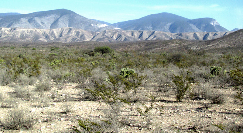
Hiking up the one-lane dirt road heading south from Higuerillas toward La Florida, about 2kms south of town the road leveled out and in the late afternoon, looking eastwards with the Sun at my back, the above was seen. The semidesert plain gently sloped downward until meeting the horizontal, gray range of upland forming a wall, or escarpment, about 8kms away (5 miles), with higher mountains rising directly behind the escarpment.
Referring to a Mexican government geological-mining map, the Carta Geológico-Minera San Pablo Tolimán F14-C57 Querétaro, I see that the mountains in the background are composed of rocks of the El Doctor Formation, which the map describes as composed of limestone bedrock deposited during the middle Cretaceous period about 98 million years ago. During deposition, material now forming the El Doctor Formation would have been below an ocean floor, only later to be uplifted into mountains.
The white splotches on the mountains are marble quarries, marble being hard, crystalline, metamorphosed limestone. The whole general area is known as the Zona Marmolera de Vizarrón, the "Vizarrón Marble Zone;" Vizarrón de Montes is a nearby town famous for its marble products. Wikipedia's page in Spanish profiling the town says that Vizarrón's main products are floor tiles, tables, sculptures, bathroom mosaics and artisanal items.
In the picture, below the bluish mountains, the west-facing escarpment is composed of a geological unit known as the Soyatal Formation, named for the nearby town of El Soyatal. According to a poster presented by Edgar Juárez-Arriaga and others at the AAPG 2016 Annual Convention and Exhibition, entitled "Soyatal Formation and Related Strata: Onset of Sedimentation in the Cretaceous Foreland-Basin System, Central Mexico," the Soyatal Formation consists of sandstone-poor synorogenic turbidites.
Turbidites are deposits of turbidity currents, which are underwater currents flowing swiftly downslope; they're deposited in deep ocean troughs. The term synorogenic refers to a process occurring during an orogeny, orogenies being mountain-building processes. As to be expected, the escarpment's Soyatal Formation was deposited later than the mountains' El Doctor Formation material, the map indicating an age of somewhere around 80 million years ago. I visualize this formation as being deposited as the Mountains' El Doctor Formation was pushed upward by forces within the Earth associated with plate tectonics.
In the picture, the escarpment's Soyatal Formation turbidites transition into what's seen in the foreground -- gray, fine-textured particles mixed with sandgrain-size ones, and larger rocks of various sizes. The map characterizes this as a deposition much younger than those of the mountains and escarpment; it was formed during the late Pliocene and early Pleistocene epochs, maybe about 2 million years old. The map describes the deposit as composed of a conglomeration of mixed-size particles, and sand -- conglomerado polimíctico-arena.
Earlier we looked at a roadcut through the Soyatal-Mezcala Formation, where we saw that these Eastern Sierra Madre mountains are an expression of what's often known as the Mexican Fold and Thrust Belt. Wikipedia has a detailed Fold and Thrust Belt page. With this in mind, the above picture tells a good story. It says that there was an ocean floor made of deep layers of calcium-rich muck. Over millions of years, the muck solidified into rock, which was uplifted into mountains. The mountains eroded, depositing thick beds of sediment in a plain at their bases. Over time, this whole region was compressed from the sides as tectonic blocks ground into one another, causing tilting, rising and sinking, faulting and folding of strata, and -- not evident in the picture -- even scattered volcanic activity.
The above picture was taken while standing beside the tent in which I slept that night, the stars dazzling, the semidesert silent, the ground beneath me sharing its stored-up solar energy deep into the night, even as the extreme low humidity brought on crispy-cold night air.