PLANTS | ANIMALS | ECOLOGY | FUNGI | GEOLOGY | GARDENING | TOOLS
MEXICAN PLANTS & ANIMALS HOME

Excerpts from Jim Conrad's
Naturalist Newsletter
Entry dated March 8, 2024, from notes taken on hill about 2kms west of Higuerillas, Municipality of Cadereyta de Montes; N20.9093°, W99.7859°, elevation ~1740 meters (~5700 feet); local narrow belt of vegetation constituting an extreme southern extension of the Chihuahuan Desert, Meridional Subregion; central Querétaro state, MÉXICO
VENTIFACTS ON SAN JUAN DE LA ROSA FORMATION GREYWACKE
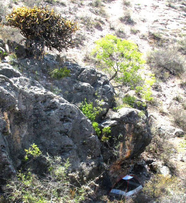
About 2kms west of Higuerillas, just south of Hwy 100, a small hill's base is composed of compacted volcanic ash, or tuff, but the hill is capped with the much harder, dark gray rock shown above. The gray rock outcrops sometimes form cliffs such as the one shown above, at the base of which I camped overnight; my tent appears at the lower, right corner.
In the picture, the outcropping rock overlooking a larger area of gently sloping landscape shows the boundary between two very different geological units. For our botanizing, this was of remarkable importance, for in the surrounding gently sloping landscape very few plants bore leaves or were flowering, while on the isolated island of hilltop gray rock, several flowering and leafy plants were found not occurring below. Affecting flowering and leafing-out in both geological units was that currently the region is experiencing a continuing long-term weather pattern designated by the North America Drought Monitor as a D3 Extreme Drought.
In the picture, just to the right of my tent, the boulders of fallen-away gray rock displayed the surface features shown below:
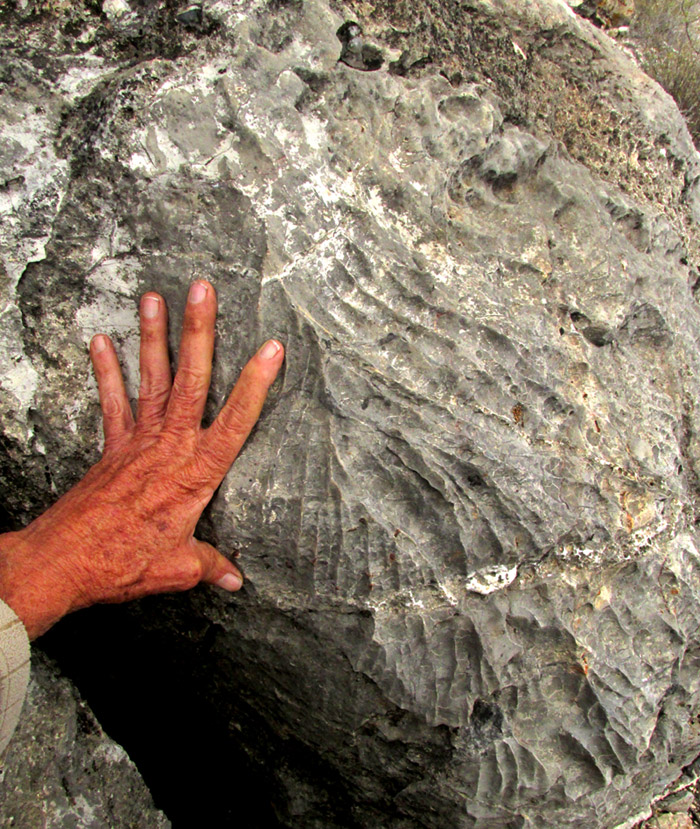
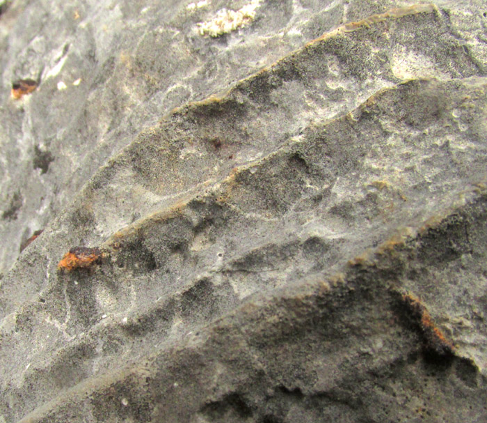
Here's a closer look at the ripples, showing that the rock matrix is somewhat grainy, not smooth:
Especially because such rippled features were limited to this small area particularly exposed to wind blowing up and down the valley, I guessed that the features were caused by wind erosion.
An Internet search for images of wind-caused erosion on rock faces makes clear that wind can produce a tremendous variety of rock-face features. Such features are referred to as ventifacts, and some images of ventifacts are similar to what our pictures show.
Satisfied that our pictures show a particular, ripply kind of ventifact, I was still curious about the gray rock itself.
The Mexican Government's 1998 geological-mining map entitled "Carta Geológico-Minera San Pablo Tolimán F14-C57 Querétaro" clearly shows the islands of hard, gray rock capping this and other hilltops 2kms west of Higuerillas. It designates our hard, gray rock as part of the Formacion San Jaun de la Rosa, the San Juan de la Rosa Formation. The rock's age is given as from the Jurassic Period, deposited sometimes between about 180 and 140 million years ago.
The 2014 Master's thesis of Leticia Millán Sánchez entitled "Caracterización Geométrica de la Deformación de la Formación San Juan de La Rosa (Jurásico), en el Área de Tolimán, Querétaro," describes the San Juan de La Rosa Formation as largely composed of sandstone, along with lavas, tuff, fine-grained sedimentary rocks called lutites, conglomerates and thin layers of evaporites composed of crystalline salts caused by evaporation of salty moisture from the ancient soil surface. I would have thought our dark gray rock was basaltic lava, except for the white splotches and streaks, and the absence of vesicles, which are holes in basalt rock formed when lava lithifies into rock. Discarding the basalt possibility, our dark gray rock must have been sandstone.
The author further writes that various kinds of sandstone occur in this formation, including sedimentary rocks known as sublitharenite (sandgrains in less than 15% mud matrix), greywacke (more than 15% matrix), arkose (very coarse-grained), quartz arenite (more than 90% quartz fragments) and lithic arenite (less than 5% sand-size fragments from other igneous or metamorphic rock types) -- "... sublitarenita, grauvaca, arcosa, cuarzo arenita y litarenita," as she writes it.
In the US I grew up in the center of a geological region known as the Western Kentucky Coalfields, where the main bedrock was sandstone interbedded with coal. The Kentucky sandstone, of late Carboniferous age (a period known as Pennsylvanian in the US) was about twice as old as this Jurassic rock, and looked different from it. The Kentucky sandstone lacked the high amount of very fine-grained matrix material separating individual sandgrains. Apparently our gray, Mexican rock was one of the various forms of sandstone mentioned above. Of those types, pictures of one look exactly like our gray rock, that of greywacke.
New Zealand sits atop a great deal of greywacke, and "The Geology of Auckland" website page about greywacke tells us that "Although greywacke can look similar to basalt, it differs in that it is commonly veined (with quartz being the vein mineral), and lacks vesicles." The greywack in our pictures looks like basalt, except for those white veins and splotches occurring throughout, and it lacks vesicles.
The large amount of fine-grained matrix material in which our greywacke's sandgrains were enmeshed leads to more of our rock's story. For a long time, greywacke remained a mystery because in flowing water -- and greywacke is water-deposited -- when sedimentation takes place, larger grains settle to the bottom first, then the next larger grains, etc., the sediment gradually sorting its particles. In other words, tiny particles forming mud don't end up mixed with larger, sand-size particles. But greywacke was a mixture of mud and sand.
Greywacke now is understood to be formed during underwater avalanches or strong turbidity currents, when sorted particles become mixed together into a slurry. When that mixed-up slurry turns to rock, it forms greywacke.
Supporting this insight is that greywacke deposits occur on the edges of continental shelves, at the bottom of oceanic trenches, and at the bases of mountain formational areas. Our Querétaro greywacke was deposited at the start of the formation of the Eastern Sierra Madre mountains.
The ocean floor was pushed upward by tectonic forces within the Earth. During this upheaval the ocean floor was tilted, causing underwater avalanches of sediment. As the rising continued, the ocean floor became dry land which was subject to more tilting, folding, faulting, as well as being covered with vast amounts of volcanic ash and lava.
Then came the mostly limestone Eastern Sierra Madres, and erosion, leading to the little valley in which Higuerillas now stands, where 2kms west of town hills are capped with hard greywacke, on which in its most exposed locations its surface can be eroded by wind into ripple patterns.