DESOTO COUNTY
On US 61, from the Tennessee
Border go for 11 miles and then take a left onto MS 3.
Traveling southward here you are on flat land comprising the Mississippi River
Floodplain, where here also is the northernmost part of the region referred to as the
Mississippi Delta Region. At this point, our loess bluff pulls away from the
Mississippi River and will not return to the river until Vicksburg. As you travel
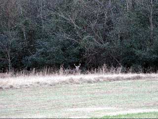
this flat land, notice on your left, toward the east, how the usually wooded loess bluff
rises conspicuously from the flat ground. It is a very striking feature.
From US 61, follow MS 3
for 4 miles the intersection with MS 304, and turn left.
From MS 3, travel eastward on MS
304 for 5.5 miles to Eudora, and turn right (south) onto MS
301.
About midway through this section you abruptly climb back into the hilly loess section --
abruptly leaving flat fields of soybeans and cotton and entering rolling hills of oak and
hickory forests and pastures. Begin looking for pines to appear in the forests.
From Eudora, follow MS 301
southward for 6.5 miles to Arkabutla Lake. Toward the southern end
the road jags hard to the left. Just follow signs to the lake.
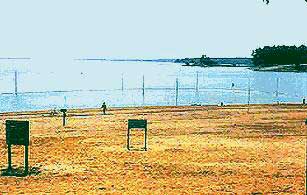
Arkabutla
Lake, with over 11,000 acres of water and a 134-mile long shoreline, and
being only about half an hour from Memphis, is a popular lake -- though on a sizzling
mid-summer, mid-week afternoon, the beach can be fairly empty, as the photo below shows.
Each year over 2,000,000 people visit this lake. We have a map
of the dam area.
TATE COUNTY
From the dam, continue south on the main
road for about a mile, then turn right onto Bundrum Road.
Continue on Bundrum Road
for about 1 mile, then turn left onto Bend Road.
Continue on Bend Road for
about 2 miles, then turn right onto Moore Road, which
may be unsigned.
Continue on Moore Road for
about 1 mile, to where it turns into gravel. Keep going on what always appears to be
"the main road" as it snakes around, and theoretically becomes Bluff
Road.
Bluff Road ends in 1 or 2
miles at Prichard Road. Here go right about 100 feet, then left,
and find yourself again on Bluff Road.
Continue on Bluff Road as
it meanders for about 4 miles, where you turn right at Arkabutla Road.
On Arkabutla Road continue
for 3 miles. When the road splits at the Y in Savage, take the left and
soon encounter MS 3.
The above complex navigating could be much simplified if upon leaving
Arkabutla Dam you stayed on the main road south from the dam to Arkabutla, then turned
right (southwest) onto Arkabutla - Savage Road, and continued to MS 3. However, then
you would miss seeing the classic loess-bluff topography right at the edge of the loess
bluff as you traveled on Bluff Road.
From Savage, follow MS 3
south for 9 miles to Crenshaw, and turn left onto MS 310.
PANOLA COUNTY
The following route gets hard to navigate in some
places. Also, on the gravel/sand stretch named Sand Bed Drive, in some places the
road deteriorates so badly that it should not be attempted if it has rained
recently. At Crenshaw some travelers may be best advised to use their state map and
navigate by larger but much less interesting roads to Enid Lake, our next main
destination. Note also the presence of Sardis Lake and John W. Kyle State Park about 6 miles east of Sardis.
See the detailed Sardis Lake Map.
At Crenshaw, follow MS
310 east for about 1000 feet, then turn right (south) onto Old Askew Road,
then travel another 1000 feet and turn left (east) onto an unsigned paved road 1½ lanes
wide. A concrete marker here points toward the landfill.
Continuing on the unsigned road for about 2
miles, turn right onto Indian Creek Road.
Indian Creek Road turns to gravel in about
a quarter of a mile, then in about 4 miles ends at MS 315, on which you turn left.
On MS 315 go only about 3/4-mile, then turn
right (south) onto unsigned, asphalt road to Delta.
On the unsigned road to Delta, go about 3
miles to Delta, then turn left onto the unsigned asphalt road.
Stay on the unsigned road out of Delta for
only about 1 mile, then turn right onto the rough gravel road called Sand Bed Drive.
On Sand Bed Drive continue about 2 miles
and take a left onto Ballentine Road, which is paved.
Here you are following along the very base of the loess bluff in a nicely
graphic manner. The creek along your right (west) is Peach Creek.
Stay on Ballentine Road
for about 1.5 miles, then turn right onto unsigned gravel road, which
later on is signed as Macedonia Road.
On Macedonia Road, which
becomes paved midway, continue for 6 miles to MS 6, and here turn left.
On MS 6, travel east for 1.5
miles, and turn right onto gravel McDowell Road, or, to avoid confusing
navigation, continue eastward 9 miles to I-55, then go south and at the second exit follow
signs to Enid Lake.
The creek you cross immediately upon embarking onto MS 6 is what is left
of the Little Tallahatchi River, the damming of which created Sardis Lake about 18 miles
to the northeast.
Continue on gravel McDowell Road
for about 2 miles, to paved Chapeltown Road, and
continue to the right (south) to Tocowa Road.
Here roads are poorly marked and numerous. Just "follow the
main road" southward or southeastward. If you get lost you'll eventually hit MS
35, and then you can use your state map to get to Enid Lake.
Follow Tocowa Road for
nearly 3 miles, then turn right onto MS 35.
On MS 35 go about 1
mile and turn left onto unsigned road.
Stay on this unsigned road for about 1.5
miles, then go right onto another unsigned road which may be Benson Road.
Follow Benson Road for
over 3 miles, crossing Long Creek, to Crowder-Pope Road, and turn left.
On Crowder-Pope Road, go
about a mile, to Pope. Continue eastward through Pope, to US 51.
Follow US 51 south 4.5
miles, to signs pointing toward Enid Lake.
YALOBUSHA COUNTY
Follow signs beneath I-55, for about a
mile, to Enid Lake Dam.
Enid Lake, with exceptionally easy access from I-55, is a 6,100-acre
lake with 65 miles of shore line, and all the amenities you'd expect of a recreation area
administered by the US Army corps of Engineers. Lake Enid is famous for its fishing
-- White Crappie, bass and catfish. The world record crappie was caught at Enid
Lake.
Leaving the dam area, return the way you
came, to I-55's Exit 233.
The next town visited is Charleston, 12 air-miles to the
southwest. By far the easiest way to get there is to take I-55
south to Exit 227, then follow MS 32 west to Charleston.
However, this would miss some attractive loess-based hill-country just to the west.
If you wish to continue southward by backcountry roads, continue below I-55 a few
hundred feet to US 51 and on US 51 return north to Pope,
follow the road through town you earlier took, leaving town toward the southwest, on Crowder-Pope
Road. After about 4.5 miles, turn left (south) on Teasdale
Road and continue "following the main road" as it twists and turns all
the way to Charleston, some 13 miles.
TALLAHATCHIE COUNTY
Entering from the north on Teasdale
Road, just follow the main road as it twists and turns all the way south to Charleston,
some 13 miles from the road's beginning. Inside Charleston,
Teasdale Road is known as N. King Street. At the end of the road, inside Charleston, turn
right (west) onto MS 32.
Proceed through Charleston to the
intersection with MS 35, and turn left (south).
Heading south through Tallahatchie and the next couple of
counties to the south, it is possible to pass through some of the most pleasant
backcountry scenery along the entire Loess Bluff Route. Many roads in this area are
gravel but they are well maintained. These gravel roads form a veritable maze
impossible for outsiders to navigate, because they are nearly always unsigned. See
our "Navigating by the sun" section.
Having read the above, make your way
through Tallahatchie County's southeastern corner as best you can. The easiest way
is to follow MS 35 south from Charleston to Holcomb, following closely
the base of the loess bluff, but the prettiest landscape lies just to the east of MS 35,
with its unsigned maze of gravel roads.
(South of Charleston, one way to enter the upland maze of mostly gravel
roads is to cross Tillatoba Creek immediately south of town, then embark on the first
asphalt lane to the left (east). Signs directing toward the Tallaha boy Scout Camp
may be present. After that, just drift southward, "following the main
road," and congratulate yourself heartily if you manage to pass through Cascilla, and
ultimately pass into Grenada county, and meet with MS 35, and turn left, toward Holcomb.)
GRENADA COUNTY
The Loess Bluff Route passes through the narrow western toe of Grenada
County, but the most scenic backcountry roads are typically unsigned and maze-like.
Moreover, since the Yalobusha River runs north of Holcomb, and Potacocowa Creek lies just
south of the county line, "navigating backcountry roads" by the sun is
unproductive here, because so many roads end at the water's edge. Therefore, unless
you don't mind many dead ends, or have a very fine map you wish to try, probably it's best
just to follow busy MS 35 north and south into and out of this county.
Grenada Lake, just 3 or 4 miles northwest of Grenada town, is a
10,000-acre lake with 54 miles of shore line, and perhaps even a greater assortment of
recreational amenities than you'd expect of a US Army corps of Engineers recreation area.
CARROLL COUNTY
In terms of navigating backcountry roads, Carroll County may well offer
the most frustrating experience of the entire Loess Bluff Route from Kentucky to
Louisiana. The Loess Bluff zone constituting the county's western uplands, besides having
its unsigned maze of mostly gravel roads, also presents a gorgeously rugged
intermingling of hills, little rivers and creeks, lakes and upland piney woods.
Busy MS 35 enters Carroll County from the north and goes
to Carrollton. You can continue south on a busy, well-defined highway by
going onto MS 17 inside Carrollton, leaving MS 35 from the right if heading south.
You can avoid losing yourself by staying on MS 17 all the way through the rest of
Carroll County. Yet, what a pleasure wandering the uplands just to the west of MS 35
in the north, and MS 17 in the south. But, if you do go into this unsigned mazeland,
you'll have to navigate by the sun.
HOLMES COUNTY
If you enter Holmes County from the north
on MS 17, a little over 2 miles south of Acona, or 3 miles south of the
county line, take a right onto Rosebank-Mt Olive Rd.
On Rosebank-Mt Olive Rd, "follow
the main road" for 12 miles, until it ends at MS 12,
and you turn right (west).
At some point midway this journey, Rosebank-Mt Olive Rd. theoretically
becomes CR 119, but no signs give indication of this. During the last few miles you
are right at the edge of the loess bluff.
On MS 12, proceed west precipitously down
the bluff, and in about half a mile turn left onto Howard Road.
On Howard Road go 3 miles to Howard.
Once again it becomes impossible to navigate looking for road names.
However, for most of the distance between Howard and Yazoo City, our next main
stop, there are roads of varying quality running exactly at the base of the loess bluff,
or a little into the upland. Probably the best way to keep to our Loess Bluff Route
here is to keep an eye on the bluff itself and try to stay at its base. The swampy
land at the base of the cliff comprises the Hillside National Wildlife Refuge. In
the town of Howard you may be able to commence your bluff-base travel by turning onto an
unsigned road inside town, running southward, with the bluff rising immediately to the
east.
YAZOO COUNTY
Entering Yazoo County from the north is very simple if you are following US
49E, for this major highway runs right into town. However, if you are
trying to navigate the pretty rugged country just east of US 49E and the loess face,
it is impossible to say how you will finally reach Yazoo City.
From downtown Yazoo City, travel
westward on US 49W for about half a mile, then turn left onto MS 3.
Following the loess bluff south beyond Yazoo County is simple if you you
just remain on MS 3, which goes all the way to US 61 at Redwood, the loess bluff usually
rising conspicuously immediately to the east. However, there is a more-or-less
navigable backroad route we shall now describe. On the boundary between Yazoo and
Hinds Counties the road deteriorates to the point where grass grows between the tire ruts,
so you must be mindful of recent weather and the capabilities of your vehicle.
About 6 miles south of Yazoo City, at the
barely recognizable community of Crupp, embark on a paved road to the
left, abruptly climbing the loess bluff, toward Tinsley 4 miles distant.
Just a few hundred feet below (south of) Tinsley there's an intermittent
little creek, the valley of which is used by the ICRR running between Memphis and Jackson
to penetrate the loess bluff. This little creek bed is a fine place for looking for
semiprecious stones and fossils. You will grasp the importance of fossil findings here if
you read our page about The Whales of Yazoo County.
4 miles south of Tinsley, turn right
onto Oil City Rd.
Follow Oil City Rd. for 4 more miles,
then turn right onto MS 433.
Follow MS 433 westward for 3 miles,
then turn left onto Mechanicsburg Road. (Or continue 3 more miles to MS 3
at Satartia, then follow 3 southwestward to Vicksburg, and avoid the dirt road at the
county line).
Now we embark onto the least maintained passage of our Loess Bluff Route. Basically,
"follow the main road" as it winds in a generally southwestward direction.
About 6 miles after leaving MS 433, you cross a new paved
highway. Continue across the road, "following the main road." Before
long the road turns to dirt and grass appears between tire ruts. As soon as you cross into
Warren County, gravel appears. You are successful if eventually you discover
yourself in the tiny community of Oak Ridge. Remember that at any
time if you cross a decent east-west running road, you can take it westward and soon get
on MS 3, which leads southward, easily, into Vicksburg.
WARREN COUNTY
The entry into Warren County described above follows a trail that near the county line
is so neglected that during wet weather should not be attempted. If you are
following that route and have the luck to not be lost, when you come to a crossroad, just
keep going straight, and theoretically by not ever branching to the right or
left, you will find yourself on Oak Ridge Road. Stay on Oak Ridge Road as
best you can (poorly signed) and eventually it will end in plain view of a gasoline
station and the Culkin Volunteer Fire Department. Take a right just
before the fire station and in a couple of miles you will cross busy US 61.
At this point you have the large and attractive Vicksburg National Military
Park between yourself and Vicksburg. You can navigate by
the sun toward the southwest, knowing that eventually you'll find downtown Vicksburg, or
you can pull out your state map, find yourself on US 61, and navigate to your next stop.
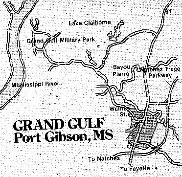
After Vicksburg, we go to the Grand Gulf Military Park.
Vicksburg is
an historic place and it has more attractions than usual for a town of its size. You may
want to review our brief outline of Vicksburg history
during the Civil War. Among the spots of special interest for the kinds of folks
making this trip might be:
The Vicksburg Information Center describing these and many other local
attractions is located on Vicksburg's south side, just north of the last exit on I-20
before crossing the Mississippi River.
Take US 61 south out of Vicksburg.
After about 18 miles cross the Big Black River into Claiborne
County.
US 61 is most easily located by taking the second-to-last exit on I-20 before the
Mississippi River, heading westward.
US61 follows the Loess Bluff face for most of its distance through the rest of Warren
county.
An alternative route out of Vicksburg is to take Fisher Ferry Road at the third-to-last
exit on I-20 about 20 miles across the Big Black River, to the Natchez Trace Parkway. Once
on the Trace, traveling about 5 miles southwest, one arrives at Rocky Springs Campground.
CLAIBORNE COUNTY
Stay on US 61 for about 6 miles,
then turn right onto Main Grand Gulf Road (at top right below).
Stay on Grand Gulf Road (keep
going straight), for about 8 miles, until reaching Grand
Gulf Military Monument Park.
Grand Gulf
Military Monument Park celebrates yet another spot along the Mississippi
where the river's approach to high loess bluffs caused it to be of strategic importance
during the Civil War. Today at this location you can visit a peaceful little park
with an observation tower, a water mill and other historical buildings, lots of trees,
camping sites, a museum and a "trading post." It also presents "the
best preserved Civil War Battlefield in Mississippi. You might like to review our
brief outline of Grand Gulf's Civil War History.
Return on Main Grand Gulf Road for
nearly 4 miles, then take a left onto paved road toward Port
Gibson.
This road immediately crosses a railroad track, then 1/3 mile farther the Bayou Pierre.
Follow this road for 3 miles to the
intersection with US 61 inside Port Gibson, and turn
left (south).
About half a mile south of Port Gibson,
take the Natchez Trace Parkway
south to its end in Natchez.
JEFFERSON COUNTY
 Follow the Natchez Trace Parkway all through the
county.
Follow the Natchez Trace Parkway all through the
county.
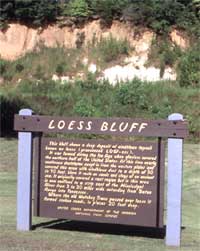
Along the route there are several pull-off areas with exhibitions, such as the one at
the right, where it unfortunately is insisted that the proper pronunciation of loess is
"LOW-ess." Here is what the sign says:
This bluff shows a deep deposit of windblown topsoil known
as loess (pronounced LOW-ess).
It was formed during the Ice Age when glaciers covered the
northern half of the United States. At this time nearly continuous duststorms swept in
from the western plains and covered this area with windblown dust to a depth of 30 to 90
feet. Here it rests on sands and clays of an ancient sea. It originally covered a vast
region but in this area is now confined to a strip east of the Mississippi River from 3 to
30 miles wide extending from Baton Rouge into Tennessee.
Where the old Natchez Trace passed over loess it formed
sunken roads, in places 20 feet deep.
ADAMS COUNTY
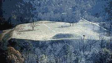
Immediately upon entering Adams county, follow signs to Emerald Mound,
then return the same way to the Parkway.
When in less than one mile the Natchez Trace Parkway
ends on US 61, follow US 61 into Natchez.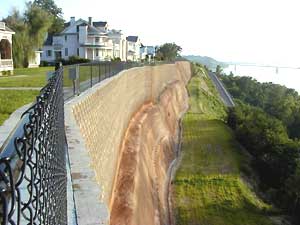
To reach the Welcome Center, which offers not only information but also some excellent
exhibits, films and programs, follow US 61 past Washington, where US 84 enters from
the left (east). Now follow signs for US 84 to right before it crosses the
Mississippi River. The Welcome Center lies immediately to the right (north) of the
last exit from US 84 before crossing the bridge. The picture here shows the loess
bluffs overlooking the Mississippi on the northern side of Natchez. You can barely see the
US 84 bridge over the Mississippi. In Natchez itself these attractions are particularly of
interest:
Heading south from Natchez on US 61, on
the outskirts of town, at the first stoplight after crossing St. Catherine Creek, turn
right onto Beltline Hwy.
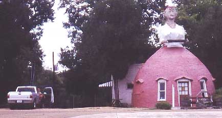
Or, continue on south on 61 for a couple of miles and have some pretty decent eating at
the Mammy Restaurant shown below.
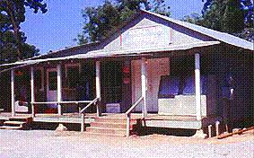
In the summer of 1999 an old fellow in Ft. Adams General Store shown at the right told
me that atop the hill before the store the foundation of the old fort was still visible,
as were gun emplacements, but they were all now inaccessibly overgrown by bushes. He had
remembered seeing them as a kid.