WEST FELICIANA PARISH
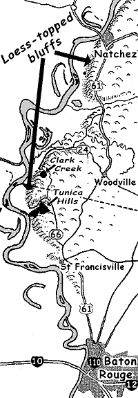 Entering from the north on LA 969,
about a mile south of the state line take a right onto LA 66.
Entering from the north on LA 969,
about a mile south of the state line take a right onto LA 66.
NOTE: This route takes you through the Tunica Hills Wildlife Management Area via a rather narrow gravel road with some very steep inclines with some spectacular cuts through the loess. If you want easier driving you may want to go left on LA 66 instead of right, and follow the road all the way to US 61, then continue south.
Follow LA 66 about 5 miles, then turn left onto Old Tunica Road, following it about 8 miles through the Tunica Hills Wildlife Management Area, paying attention to these turns:
In less than a mile, just beyond the creek, at the Y take the right.
In about 4 miles, at another Y, take another right.
At the end of Old Tunica Road, turn right.
After about 1 mile turn right onto Como Road
Follow Como Road briefly to its end, then turn right (south) onto LA 66.
Follow LA 66 for 8 miles until it ends at US 61, and turn right (south).
Follow US 61 south through St. Francisville and out of the Parish 7 miles beyond St. Francisville.
About a mile beyond St. Francisville a good side trip consists of taking LA 965 left (northeast), and in about 3 miles coming to the Audubon State Historic Site. A fee is charged for turning the 200-year-old Oakley House, where John James Audubon, artist and naturalist, sketched many of his famous bird prints. The house is a splendid example of colonial architecture with a West Indies influence.
EAST FELICIANA PARISH
Stay on US 61 for the 4 or so miles it takes to cross this little leg of East Feliciana Parish, then follow the signs to Port Hudson State Historic Site.
And Port Hudson State Commemorative Area is the southern terminus of our proposed Loess Hills Scenic & Historic Route