
Photo by Sledge Taylor of Como, Mississippi
Click on the following state
names
to view the appropriate logs:
Photo by Sledge Taylor of Como, Mississippi
 Our goal is to document a route that
travelers may take in their own cars to see the most interesting, important, and beautiful
spots in the Loess Zone, from the northernmost point, to the southernmost.
Our goal is to document a route that
travelers may take in their own cars to see the most interesting, important, and beautiful
spots in the Loess Zone, from the northernmost point, to the southernmost.
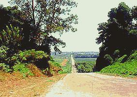
Sometimes the route follows regular highways between little and big towns, but most of the trip takes place on small country roads, where the Loess Zone's character is most vividly expressed. The road shown above is a good example. It's Prichard Road running straight as an arrow between Arkabutla and Prichard, Mississippi, about 25 miles south of Memphis. Here the road thrusts over the loess bluff, westward into the flat, soybean- and cotton-growing Delta lowlands beyond.
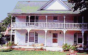 The Route also provides glimpses into a part of America long
displaced by "progress." The beautiful old house at the left stands right
next to the road about 10 miles northwest of Ripley, Tennessee. We won't overly
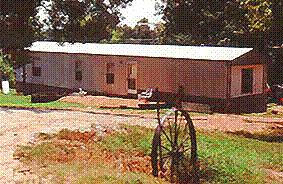
romanticize the route's architecture, however. The most commonly seen house-type is the
house trailer, no shrubbery or garden furniture, just a trailer in a sun-dazed lawn, often
with a hangdog car parked crookedly on the grass. Much of this Route exposes a part
of America not only bypassed, but neglected.
The Route also provides glimpses into a part of America long
displaced by "progress." The beautiful old house at the left stands right
next to the road about 10 miles northwest of Ripley, Tennessee. We won't overly
romanticize the route's architecture, however. The most commonly seen house-type is the
house trailer, no shrubbery or garden furniture, just a trailer in a sun-dazed lawn, often
with a hangdog car parked crookedly on the grass. Much of this Route exposes a part
of America not only bypassed, but neglected.
So, the roads comprising the "Loess Zone Scenic & Historic Route" already exist, and with the help of a printout of the various log sections, travelers can navigate the route described here.
 In most places navigation is easy, for our
description is clear and the roads are well marked. This is not always the case,
especially in some counties in central Mississippi, where county roads create a maze, and
roads are not effectively marked. We'll tell you when you may expect to get lost.
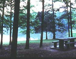
Besides, wandering the area lost you sometimes stumble onto some very nice spots, such as
the lakeside public picnic area shown at the right in northern Mississippi...
In most places navigation is easy, for our
description is clear and the roads are well marked. This is not always the case,
especially in some counties in central Mississippi, where county roads create a maze, and
roads are not effectively marked. We'll tell you when you may expect to get lost.
Besides, wandering the area lost you sometimes stumble onto some very nice spots, such as
the lakeside public picnic area shown at the right in northern Mississippi...
This log is in draft form and it is constantly being revised. Most important, you are invited to contribute to it, as you are to every section of this web site. If you know of a better route than we profile, or if you know of something we have missed, or if you have a picture we should include here, or if you can figure out a way to get through that maze in central Mississippi, drop us an email.