LOESS HILLS GEOGRAPHY
of the Lower Mississippi Valley
of the Lower Mississippi Valley
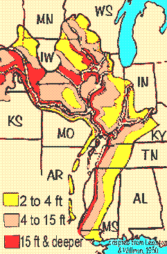 Image courtesy of "MiseDominic," made available through Wikimedia Commons.
BLUFF HILLS (green on above map, region 74a)
- Hilly landscape developed mostly atop sand, clay, and silt capped with loess more than 50ft (15m) deep
- Many micro-environments, from dry ridges and slopes to moist ravines, bottomlands, swamps; severe erosion where vegetation has been removed
- Oak-hickory forests, with less disturbed areas with beech, maples, sweetgum, basswood, hophornbeam, tulip poplar; in northern part also sugar maple and bitternut hickory, and the southern part with southern magnolia, water oak, and with Spanish moss on the trees
- CROWLEY'S RIDGE in Arkansas:
- Loess-capped hills surrounded by the lower, flat Mississippi Alluvial Plain
- Mostly forests and pasturland with limited cropland
- Post oak-blackjack oak forests, southern red oak-white oak forest, and beech-maple forests, with mesophytic species like beech and sugar maple in undisturbed ravines; shortleaf pine on sandier soils of the northern zone
LOESS PLAINS (yellow on map, region 74b)
- Gently rolling to irregular landscape with loess less than 50ft thick, thinning toward the east
- Streams and rivers are slow and murky with silty and sandy beds, and often have been channelized for draining; much erosion
- Forest, when present, is oak-hickory, but mostly it's cropland, with high levels of agricultural runoff into streams
SOUTHERN ROLLING PLAINS (beige on map, region 74c)
- Irregular and dissected landscape with less loess than in the Bluff Hills, and more agriculture and pastureland
- Forests, when present, mostly of loblolly and shortleaf pine
BATON ROUGE TERRACE (purple on map, region 74d)
- Flatter landscape than other regions, soils mixed loess and sedimentary materials, often high in salts
- Some upland hardwood forests to the northwest, other areas with "pineywoods" of longleaf pine and slash pine with saw palmetto and many evergreen shrubs and herbs maintained by fire; also flatlands with spruce-pine-hardwood mixed forests
- Urban development covers about half the region, centering around Baton Rouge
public domain image courtesy of "Muhs et al / USGS," made available through Wikimedia Commons.
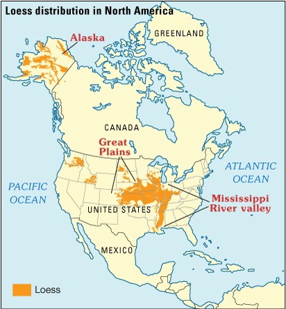
As the map at the right shows, not only do thick layers of loess occur in the Lower, but also the Upper Mississippi Valley, into the Great Plains, and elsewhere. In fact, it's estimated that about 10% of the Earth's surface is covered with loess or similar deposits. "Similar deposits" include dust not of an Ice Age, glacial origin, but rather dust blown from deserts, dune fields, dried lake beds, and volcanic ash.
Possibly the greatest deposits of all occur in China. China's Yellow River is named for the yellowish tint of its water, provided by loess particles suspended in the water. The soil in China's loess zone has been called the most highly erodible soil on Earth.